Starpath
Emergency Navigation Card
Emergency Navigation Card
Couldn't load pickup availability
8.5" x 11", 30 mil laminated vinyl, printed both sides, water resistant.
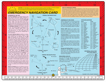
This card is intended as an addition to a back-up nav kit or just as a quick reference to emergency techniques. Davis Instruments and others have published a series of such cards on various topics, and if you have a set of these or have found individual ones useful, this would fit well into that category.
The card includes techniques of steering without a compass, finding boat speed without a knotmeter, how to find latitude from sun and stars without sextant or watch, and so forth.
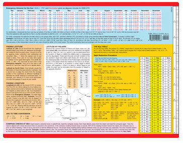
It also includes a method of sight reduction we devised for this purpose, called the N(x) table, which is, without doubt, the world's shortest sight reduction table. This reduction method takes more arithmetic than conventional tables, but they will get the answers. It is much quicker, however, to use it for other purposes such as finding the bearing of the sun or a star at any time. It does this very nicely. This table and our long term almanac for sun and stars makes this card a "complete navigation resource" in an emergency, but it takes practice to learn to use these special features of the card. We include complete instructions with each card.
Other things like steering by the stars can be read right off of it without any reckoning. All info on it except the N(x) table and the long-term almanac are included in the Emergency Navigation book, which is the basis for the techniques and information printed on the card.
Special topics on the card with full instructions include
Long Term Sun Almanac
— For finding Lat, Lon, and bearings
Table of key star declinations
— For finding Lat and bearings
N(x) Table (world’s shortest sight reduction tables)
— Sight reduction of celestial sights
— Compute bearings to celestial bodies
Latitude by Polaris
— Using unique methods provided
How to find Latitude
— By Lan
— From zenith stars
How to find Longitude
— Using UTC and N(x) Table
Arc to Time Conversion
— For finding Lon and sun bearings
Compass checks
— Using celestial bodies or flotsam
Steering by the sun
— By amplitude
— Bearing relative to local noon, without accurate time
— Bearing at any known time
— Using shadow tips
Finding boat speed with a chip log
— Using flotsam
— Using custom made log line
Steering by the stars using
— Pointer stars in all quadrants of the sky
— Orion’s belt
— Overhead stars
How to measure low angles with the card scales
— For Latitude
— For time keeping
— For piloting
Universal scale for making nautical charts
— Using plain paper and card scales
Edge protractor
— For accurate star and landmark bearings
— Relative angles for calibration and piloting
Share